The Start of My European Trip
- Mike

- Oct 24, 2025
- 3 min read
Updated: Feb 18

【October 24】
After breakfast with Vhisyhny, I headed to the station. He went to Königssee, while I headed to Mount Jenner, recommended by my German friend.

I could take a gondola from near the station or take a bus to near Lake Königssee and transfer to another gondola there, but to save on transportation costs, I opted for the plan to take a bus to the gondola's intermediate station and head up Jenner Mountain from there.


↑After leaving the station, the bus climbs a steep mountain road to a high elevation.

←The terminal bus stop on the hill is visible in the center.
Buses turn around here and head back to the station.

The hiking route starting from the bus stop turned out to be the best choice in hindsight.
This route is highly recommended for hikers.
It's a wonderful hiking route from spring through summer.
We walked along the mountainside toward the gondola central station.
Perhaps because it was off-season, there were hardly any other hikers, making for a lonely hike.↓


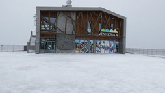
After walking for 30 minutes, we arrived at the gondola mid-station.
From the mid-station, we took the gondola to the summit station.
As seen in the photo, snow began accumulating partway up, and the wind and snow grew fierce. Mountain weather really is unpredictable.


Stepping outside after exiting the gondola, I was greeted by a world blanketed in silver, bitterly cold just from the wind and snow.
From there, a snowy path led all the way to the summit, and since several people were descending, I figured it must be safe and promptly started climbing (Below photo #2). Upon reaching the mid-slope (Below photo #3), a steep staircase stretching just tens of meters to the summit lay ahead.
Though hard to tell from the photo, the temperature was extremely low, and the blowing wind and snow were nearly blizzard-like.
I climbed about a third of the stairs, but my feet kept slipping. Although there was a handrail rope, I decided it wasn't worth risking the climb and turned back toward the gondola station.
I warmed up in the restaurant there, drank an expensive coffee, and rested for a while.


After resting, we took the gondola back to the intermediate station.
From there, we followed the hiking route down to the lakeshore below. Here too, the Mapy app came in handy, suggesting hiking routes and displaying distances and times.


Even when viewed from the lakeshore, Königssee—which had been visible through the trees during our hike—wasn't particularly impressive. According to my friend, the view from the summit of Jenner was the best.
The lakeshore was lined with the souvenir shops common to tourist destinations, and many tourists were buying souvenirs.


I took the bus from the nearby stop to Berchtesgaden Station, bought dinner and tomorrow's breakfast at a supermarket near the station, and returned to the Youth Hostel.
When I arrived at the Youth Hostel, a Ukrainian and a Canadian youth had just checked in. Then, at 8:30 PM, another person arrived.
Summary
The app ‘Mapy’ introduced to me by Vhisyhny, whom I befriended at the youth hostel, proved to be excellent.
While the Google Maps app doesn't display ropeways or mountain trains, Mapy shows them, making it much easier to plan trips.
Furthermore, tapping the mark for your destination bus stop shows the transportation network and travel time to get there, making the journey itself enjoyable.


Comments